The site, where the Old Bridge of Mostar was
located, is in the most ancient core of the town, and on both banks of the river there are
ancient stone buildings in the typical architecture style of the place, influenced by the
Ottomans. The river Neretva is quite lower than the adjacent streets leading to the
bridge, being the average river level at m.42 (a.s.l.), the average riverbed level at m.38
(a.s.l.) and the average street level at m.55 (a.s.l.). River banks, composed of natural
conglomerate rocks, are quite steep: this happen mostly on the east side, where masonry
stone walls of the buildings and rocks, (on which they are founded), make a sort of
vertical barrier to the river flows.
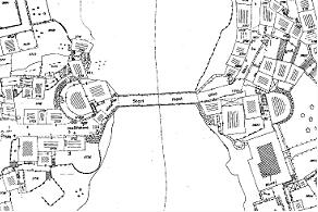
The river Neretva runs from north to south and,
100-150 metres before the bridge site, the riverbed gets suddenly smaller and makes a turn
which leads the flows more towards the east bank.
Most probably the site for the bridge has been chosen, in the ancient times, because it
was the most narrow point in the area where it was possible to cross the river, and
because of the high and stable rocks located on both banks. But being, in that spot, the
riverbed of smaller size, like in a funnel, the flows get faster, stronger and higher,
enough to cause frequent damages to the abutment walls and to threaten with the buildings
at the street level. This is the reason why the old bridge steep flooring, (about 20%),
was higher than the adjacent streets level: to avoid river water thrust during the floods.
The accessibility to the site is quite limited by the narrow streets, (ulica Kujundziluk
by the east side and ulica Oneskukova by the west side); residential buildings, being
located by the river banks, have their entrance doors by the street side and do not even
allow, close to the bridge, the visibility of the river and of the surroundings.
The river Neretva has got a torrential regime and its waters get easily and suddenly
strong and high even during one single daytime. River water levels, anyhow are very much
influenced by the seasons: during the dry season it is possible to see the rocks along
both of the banks and to see the foundation levels of the abutment walls. While during
floods the river may reach very high levels, and even in recent times, it has been
possible to observe the river so high to cause damages to the houses located by the banks.
In January 2000 a flood caused the collapse of the temporary gangway, (footpath), located
approximately at the adjacent streets level, and many other damages, (among which the
collapse of the Kriva Kuprija bridge).
The riverbed, immediately after the Old Bridge crossing spot, gets much wider and the
Neretva receives its tributary: the river Radobolja; moreover, many other small rivulets
fall in the Neretva along the site mostly from the west side before the bridge.
In the spot where the bridge used to cross the river, founded over the rocks, two huge
masonry structures rise: they are wedge shaped to face the river flows and they are
supposed to work like a funnel. On the top of them there are located some small buildings,
and other fortification structures, among which the two facing towers Halebija and Tara on
the opposite banks, characterise the whole area with their peculiar shape, which is flat
towards the river and round towards the territory.
The whole appear to be castled, narrow and perfectly inserted in the morphology of the
site: masonry structures are not only founded over the rocks, but they are actually
winding the ground and they prosecute, either upstream, either downstream, melting with
the river-rocky-banks. At the top, the abutment walls, with no discontinuities and no
decorative elements, sometime become the elevations of the residential buildings with
small windows and with the typical stone roofs.
Vegetation groves everywhere: rocks and walls are covered by green bushes and leaves: it
is difficult to understand where the nature ends and the stone structure starts, being the
walls built in tenelija stone and in natural conglomerate like the rocks.

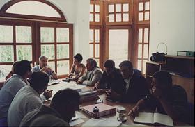
The
technical meetings
Until the and of August we had ten official
technical meetings. They are held mostly in Supervisors premises. The standard
participants are:
- PCU
- Technical Assistance
- UNESCO
- Supervisor
- Contractor
If required, the guests in these meetings are also the experts from different areas (Power
Plants, City Waters, etc), previous Contractors (General Engineering, LGA, etc) the
subcontractors, and all other necessary persons and institutions.
 |
 |
| technical meeting n°3 |
technical meeting n°5 |
 |
|
| technical meeting n°8 |
|
The
scaffoldings
On 12.07.2002 we started with the erection of the
scaffolding for the side walls. This scaffolding is necessary for the reparation works on
these walls.

 |
 |
| the scaffolding on M5 |
|
We started with scaffolding on west
downstream wall (M5c, M5b, M5a), the upstream wall on the same bank followed (M3b, M3a),
then we crossed the river and finished the left bank M4 upstream wall. Now we are making
the preparations to erect the scaffolding on the two remaining walls on the downstream
east side (M6 and M9).
In the mean time, our workers started with cleaning of the joints on these walls. That
item is very important for the injection works which will start soon. After this cleaning
job, damaged stones will be repaired or changed for new ones if required, and then the
joints will be re-pointed. When the surface of the walls is solid enough, the injection
works will follow.
Drillings for the
foundation of the crane
After determining the best possible position for
placing the main crane, investigations of the soil under the foundations was made.
 |
 |
| drilling
machine |
hole on the upper part of the rock |
 |
 |
| drilling
results n°1 |
drilling results n°2 |
 |
 |
| drilling
results n°3 |
drilling results n°4 |
So, four deep drills were made on
spots were the crane foundations were supposed to be established. The approximate depth of
the holes was 6 meters.
As the pictures are showing, the results of these tests were satisfying, the soil is
strong enough, and the production of the foundations already started!
On four concrete blocks, the wooden
deck will be installed as the base for the trails of the crane POTAIN GMRT 486 A, with
range 50m, max weight 1.3 tons at the end of the boom.

Laboratory testing of
the materials
As the preparations for bridge construction started,
one of the first steps is to find and determine proper materials. They must fulfill many
conditions: strenght, size, colour, chemical characterist, etc; if not the same - they
must be as close as possible to the ones used on the Old Bridge.
At this moment tests of stones for masonry (breca,
krecnjak, conglomerate), lime stone and sand are ongoing.

Traditional 436. Dives
from the Old Bridge
On Sunday, 24.08.2002, the 436. traditional dives
from the Old Bridge were held. This Year 33 divers in ‘legs first’ and 14 in
‘head first’, took part in this competition. The winners are Ermin Zukanovic and
Haris Dzemat, both from Mostar. The Constructer of the Reconstruction of the Old Bridge
provided the platform for dives on it’s own expense.


