| ARCHITECTURAL ANALYSIS AND SURVEYS | English
|
|
5.7 Geometry determination of thickness dimensions and of projecting elements. The ancient documentation is poor of cross sections and of thickness dimensions (like the thickness of the bridge) and of dimensions of the projecting elements (like cornices), moreover there is no data concerning all the "small" dimensions of details and of variations. This of course constitutes an important limit to the exact global geometry determination, and these elements have of course a remarkable esthetical architectural value. Inaccuracies in the geometry determination of these dimensions may lead to a different global aspects of the monument. For what concern the bridge thickness of the load bearing arch, it can be said that it was most likely that this measure had small variations and changes in the bridge length due to usual constructive inaccuracies and imperfections. The 1982 survey doesn’t allow any evaluation of these variations probably because of the graphic representation scale, and nowhere else these information are filed. By summing up all the thickness dimensions of every single stone row, the results are in many cases far from being reliable, because these totals are often too much different from the average value of the thickness, and the differences do not follow a progression. This is also due to the fact that voussoirs have been measured one by one, but no global dimension has been taken, therefore there might be an inaccuracy related to the joint thickness and to the reiteration of the measures for a number of times equal to the number of arch stones contained in each row. Therefore the thickness of the load bearing arch of the bridge may be evaluated from the 1982 survey as 395 centimetres, which is also the average value obtained from the totals of the 1955 survey. During the on site works ordinary constructive imperfections will lead to the performing of the small differences among row’s lengths. For what concern, instead, the study of the cross sections, and of the dimensions of the cornices, the phase A work has led to understand that these data may be only gathered trough the analysis of the recovered stones, and of the remains of the former bridge. A study of this peculiar aspect has been completed, and has led to some drawings, which have to be considered the reference sections towards the determination of the most likely dimensions for all the architectural finishes. The analysis work of the recovered stones has been performed either during Phase A either during phase B of the works, and with the support of technical notes written during the performing of the ancient restoration works it has been possible to reach a satisfactory level of accuracy.
5.8 Geometry determination of the spandrels, cornices and parapets For what concern the other bridge elements geometry, like spandrels, cornices and parapets, it has been mostly referred to the 1982 survey. But performing all the necessary checks (like it has been done for all the work steps) some incoherences have been found, as it has been already explained in the paragraph §1.2.2 of phase A report. The most remarkable and reliable checks have been performed trough the use of the photogrammetric elaboration of the ancient pictures (refer to paragraph §5.3 of this report). All the differences found have been documented in a sort of superposed representation drawing, on which importance has been given also to the 1955 survey dimensions. The above task has been performed in a cad system, where all the data have been easily compared in the appropriate scale. Data pertaining to the photogrammetric processing (rectified pictures) have been imported as raster images and, in overlay, vectorial digital drawings have been remounted and compared. It should be underlined that, for what concern the spandrel stone layout, inaccuracies have been found mostly on vertical joints, while horizontal ones were correct: this is probably due to the scarce visibility of details and of short and small divisions. Cornices dimensions constituted a more difficult issue to handle since for small elements the graphic sign (of the ancient drawings), shadows and low level of visibility may have led to remarkable inaccuracies. Anyhow it seems that the size and dimensions of cornices, even if similar, were not constant and there was a difference among the upper and lower cornices of the bridge elevations. This matter is strictly linked to the study of the thickness of the mentioned cornices (see previous paragraph) and has been better analysed during the phase B for the stone cut (refer to chapter 7 and to SC-XX drawings). A procedure has been worked out to make those elements as much close to the former ones and to manage at the same times tolerances, joints and slightly variations among one and another. The above process has allowed a satisfactory level of accuracy, and what is most important, has strongly contributed in the determination of the most likely geometry of the bridge, stone by stone, trough a sharp analysis of the available data and elaboration. The value of this work is independent from any other future use of it, may not even be related to this project, because this is an historical and research contribute for a monument that doesn’t exist anymore and that is lost forever.
5.9 The bridge curvature inquiry Arch voussoirs laying one next to the other are represented in the 1982 ancient surveys by a division line that here next will be called "joint line". Joint lines have different orientation that generally converge in one or more points which are the arch centres. In the specific case of Mostar Bridge, this orientation varies depending on irregularities due to craftsman inaccuracies or due to the bridge settlements and deformations. It has been verified that, for the following reasons:
it has been of use to work out which are the centres of circles that best fit the points of the arch curve and where groups of connection lines are oriented to. This elaboration has produced important reference lines that outspreading form the centres have been compared to the joint lines of the 1982 photogrammetric survey. To perform the above task it has been designed a purpose built software routine that having as input data the X,Y co-ordinates of groups of points of the intrados line (belonging to the final mediated curve), outputs as feedback the centre co-ordinates and the radius of a circle that best fits the given points of the arch. This inquiry, as first result, has given the possibility of drawing voussoirs joint lines with a better control and has avoided the eventual graphical inaccuracies due to the thickness of 1982 drawn lines. The arch intrados curves, of north and south side, have been also mathematically investigated using the numeric values of all the joints co-ordinates. But being the curve so much affected by local irregularities this task hasn’t given meaningful results: a mathematical equation that could partially fit all the numeric data may only be represented by a polynomial function of high exponential level. This curve would be of very little use for the current study or for the on site work, and anything that is related to these considerations has been already underlined (see §1.9.1 of the Inception Report). Going back to the above mentioned inquiry, it has been found (by geometrical constructions verifies) that the arch had clearly some discontinuities (cusps) and that groups of voussoirs could be created being their joint line directions converging in small areas. As it has been underlined, a purpose built routine has been made to work out which were the circles and the related centres that could best fit the groups of points of the stone arch joints. The routine code is here next listed: % Calcolo della circonferenza piů probabile considerando gli scarti senza segno The routine works by running different nested loops with a chosen step in a predefined range for three different variables: X value of the centre, Y value of the centre and R radius of the circle. The routine tries, this way, many circles and compare them with the matrix of the co-ordinates of the intrados curve a[…] and b[…]; another cubic matrix (3d) is than created, composed by all the differences resulted, the lowest combination is the one that best fits all the data. With the use of this routine it has been possible to make many attempts that have contributed to a better understanding of the geometry of the intrados curve; moreover this research work may be useful during the bridge stone design, the centering design, on site works and for any future evaluation about the correct functioning of the arch stones due to their orientations: all this will be better investigated during the design phase. An interesting observation about the results of these inquiries is that there seems to be a relationship among the cusps of north and south elevations, because of the number, the location and the distance (refer also to §5.6.9). One of the hypothesis, (by Mr Pequeux), is that the cusps may have been originated by the joints of the ancient wooden centering which had sectors that could not be longer than the available wooden beams.
5.10 Graphic representation of the analysis and of the results The graphic elaboration have been detailed planned thinking of the future development of the work. Graphics and drawings have been all performed in a digital cad system to allow the following:
Moreover, as it as already been explained (see §5.6 of this report), it has been carried out a sort of relationship among graphic and numerical work trough which it has been possible to perform verifies and checks, and the system was so strictly linked that some of the results have been worked out trough the numerical work and some others trough the graphic work, depending on the type of researches. The drawings, (apart from all the photogrammetric graphic outputs and elaboration), may be subdivided in two main categories:
The first group, containing all the graphic information related to the bridge arch, has been managed with only one file, and it is the one that is mostly linked to the numerical analysis file: this choice, of course has led to a complex organisation of the final charts and of the layers but it has all the following advantages:
As already explained in the Inception report (see §2.5) the chart layout has been organised with many dimensioning systems (including this way all the numeric data), and with metric reference of different types, like cross points reference, graduated lines and graduated goniometer to make the drawings exhaustive and of easy interpretation. The second group of drawings has been carried out trough the use of a set of 3d seed drawings (see next paragraph) from which have been assembled different cad files to manage the archivolt and all the other bridge elements like spandrels, parapets and cornices and for a better study of the joint among bridge and its abutments. All the graphic drawings have been detailed analysed in this report in chapter 10 with a comment and an explanation on each view.
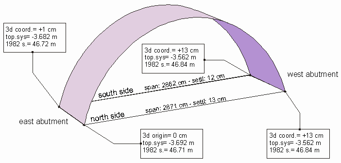
5.11 The 3d reference seed files and the bridge springers The 3d digital drawings of the bridge are one of the most important graphic elaboration for the correct management of the delicate design phase. In no other way it is possible to have a full control of co-ordinates and of the reliability of the final result, this because the 3d drawings are the result of 3d virtual digital model of the bridge and of its stones. The strategy for managing all the 3d information is different from the one adopted for the 2d drawings but the aims are similar: to have the possibility of comparing and managing all the available data at the same time. The 3d data files have been divided into seed files or basic files that contain fundamental and unmoveable objects like springers, topographic points and arch intrados curves. Some of this 3d seed files are built trough the use of portions of 2d drawings and remounted in 3d co-ordinates on the right positions. All these 3d files have one common peculiarity that links them one to each other: they are equally referenced in the space, and this allow their loading one over the other mounting a global view of all the elements. This different procedure has been followed for the 3d files because some of the drawings and of the detailed views require large computer resources, and not all of the drawings require to have all the work loaded at the same time. Moreover the method of the seed files has allowed the simultaneous working of more people on the same 3d model producing different results that could be combined at the end. The most important 3d file is the one of the bridge springer position: this file has been already introduced and described (see §2.6.1 of the Inception Report); here next the description is enlarged and updated for some values that have been changed after a more detailed evaluation.
fig.33 - A sketch of the main dimensions of the springers and of the bridge span This is a very interesting matter to be investigated, since it can tell us many things on the shape of the intrados of the vault of about 4 metres thickness. Moreover without this inquiry it is not even possible to compare north and south elevation. The results are exposed in previous sketch (fig.33). The springers have the following z co-ordinates (referred to our origin station point): north east: -3.692 north west: -3.562 south west: -3.562 south east: -3.682 and referred to the 1982 origin about: north east: 46.71 north west: 46.84 south west: 46.84 south east: 46.72 So the differences are really very low among springers of the same side, and this of course makes it much easier in comparing the different curves of the north and south elevation. What it has to be noted is that on the 1982 survey the north west dimension is reported as 46.92, which is wrong, and that can be also verified (apart from current instrumental surveys) by measuring the graphic representation of the 1982 drawing. This way it seems that it was only a mistake due to drawing editing. |
|
|
CREDITS: Intellectual property of this report and of the design drawings is owned by General Engineering s.r.l.author of the text: arch. Manfredo Romeo – other contributes have been mentioned in related paragraphs © - General Engineering Workgroup - SOURCE: Final Design Report |
|